Monday, October 27, 2014

Middle Kings: As Good as it Gets

There's been so much written about this river (including 2 other posts on this blog alone - http://thenexthorizonline.blogspot.com/2013/07/drinking-from-fire-hose-in-california.html and http://thenexthorizonline.blogspot.com/2010/08/middle-fork-kings.html), that I'm going to keep this one as more or less a photo drop.  We had low flows this year (900 at rogers crossing) as a cold snap dropped the river through the ideal flow range in about 1 day.  This makes the big drops on the river much more accessible as they aren't running together, but the price is that the in between rapids entail quite a bit more boat abuse.  Regardless, this is probably my favorite river trip in the world.  5 days of world class kayaking in the grandest of settings with a beautiful and brutal hike as the price of admission.  It just can't be beat!

The beautiful hike in.  Photo: TJ
 
 JJ somewhere in the switchbacks down to Leconte Canyon.  Photo: TJ

 The Kings Canyon fish hatchery.  Photo; TJ

 Jordy on one of the first good rapids.  Photo: JJ

 Jordy finishing off the waterfall gorge.  Photo: TJ

 Ari blasting out of the Willie Kern Meltdown drop.  Photo: TJ

 And blasting through the bottom half of a burly boulder drop shortly downstream.  Photo: TJ

Small waterfall below Raw Dog Falls.  Photo: TJ

Final move of the sweet gorge above Simpson Meadow.  Photo: TJ

 The splendid Tehipite Dome.  Photo: TJ

That's all folks.

Friday, September 12, 2014

Upper Cherry the Hard Way

Sometimes victories earned over extra obstacles are the sweetest; however, in the case of Upper Cherry Creek, the standard version involves an 11 mile hike to the put in, providing plenty of suffering for even the most hardened masochist. Unfortunately, the Rim Fire of 2013 burned large sections of the Stanislaus National Forest, resulting in subsequent closures for the summer of 2014. Despite that the Upper Cherry Canyon remained unburned (it's hard to burn granite), the roads used to access the put in trail and take out at Cherry Lake were closed, so we hatched an alternative plan.

Bourland Meadows, a trailhead on the west rim of West Cherry Creek, was still accessible and was only about 4 miles from Upper Cherry Creek as the crow flies. After a quick look at the satellite images for the area we discerned that most of the hike could be done on open granite and there was a small pass between West Cherry and Cherry Creeks we could use to prevent significant additional elevation gain at the expense of extending the hike to 4.5 miles. So we had a way in, but the way out was not pretty.

The closure extended to just above the confluence of West Cherry and Cherry Creeks, and all potential access points further down towards the lake were also closed. Sometimes lack of options brings clarity. We would be taking out just above the confluence and hiking back up the West Cherry Canyon to Bourland Meadows, a hike of 7 miles and about 2500 ft. gain with no trail but significant open granite. And that was the plan. We knew it would be brutal but there weren't any other options for kayaking in California, so we we're in. We tried briefly to wrangle a few others in, but no one was convinced about all the off trail hiking, so we set off as a team of two.

We were planning to hike one day, kayak a day and a half, and then hike out that afternoon. Instead we got an extremely late start out of Sacramento, resulting in having to call ahead for our wilderness permit since we weren't going to make it by the 5 o'clock close. The open roads to Bourland Meadows were pretty burly and we didn't arrive until 7:30 pm, so we decided to camp there and start early for a two day mission.

We didn't wake up quite as early as planned, but we were still walking by 8 am. We started out on the trail, figuring we had almost a mile until we'd be breaking off based on topo maps. Instead, the trail kept going the direction we wanted to head, so we kept following it for about an hour until we gained an expansive view of the West Cherry canyon. We did a quick map check, confirming the notch we saw upstream and on the far side of the valley was what we wanted, and took off down the slab aiming for just below a forested section of creek. We quickly reached the creek and hopped in our boats to cross to keep our feet dry before continuing upstream across the slabs towards the pass. About an hour's push saw us to the pass and our first view of Upper Cherry Creek.

 JJ taking a rest on the pass between West Cherry and Cherry Creeks.  Photo: TJ

 TJ excited that we can finally see our destination.  Photo: JJ
We took a good long break at the top before heading down into the first Manzenita of the hike. There were little game trails occasionally, but there was also some serious bushwhacking. Hindsight suggests that maybe traversing left at the pass would be easier, but the 15 minutes of Manzenita wasn't too bad either. Eventually, we regained the open granite and made good time to the river while avoiding a few swampy areas. It was only 12:30 and the hike was about as easy as an off trail hike in the California wilderness could be, so we took a quick dip and ate lunch thrilled to have made the river so quickly.


TJ coming down the slabs.  Photo: JJ


TJ figuring out where to navigate this swampy area.  Photo: JJ


Our put in.  Photo: TJ

After lunch we geared up and hopped in our boats, not knowing exactly where in the run we were other than we were below the put in slide and above Cherry Bomb Gorge. We started off with wide open granite before things quickly tightened up into classic California slides. Soon, we reached (and portaged) our first major rapid: West Coast Gorilla. We now knew where we were and that our hike had dropped us in about half a mile above the Gorilla. We continued on with lots of great slides and little scouting since we had both done the creek 2 times previously. Despite the slightly low flow, the kayaking on Upper Cherry is phenomenal in the fun department with very little stress, so much so that we were pretty much giggling at times.

Upper Cherry gets slightly more serious as you approach and pass through Cherry Bomb Gorge, where the creek has carved it's way between two 500 ft. domes resulting in a ultra-committing canyon with no opportunity for egress. Fortunately, the boating in Cherry Bomb Gorge is of the highest quality and at low flows not too difficult other than Cherry Bomb Falls. After a quick portage to the top of the falls, we dropped in, avoiding the pothole on the wall and the subsequent weir hole. The rest of the gorge was smooth and we continued rallying down through the big slide and the teacup waterfalls above Flintstone Lake. We were all smiles as we pulled into camp with the place to ourselves and the rest of the afternoon to walk back up and lap the big slide and teacups. We cooked up a little dinner over the fire and the full moon emerged, lighting up the canyon. It didn't take much brotherly jeering before we were walking back up for some moonlight laps on the teacups.


TJ starting in on the big slide.  Photo: JJ


About to catch some air.  Photo: JJ


The bottom of the big slide.  Photo: JJ


Suns out, guns out.  Photo: JJ


This one has a nice twisting entrance.  Photo: JJ


Ready for landing.  Photo: JJ


JJ just below the big slide.  Photo: TJ


JJ on another perfect teacup.  Photo: TJ


From another angle.  Photo: JJ


Hydration is important!  Photo: TJ


The moonlit teacups under the stars.  Photo: TJ


TJ walking up for a moonlit lap.  Photo:JJ

JJ sliding under the stars.  Photo: TJ

We were up early the next morning knowing we had some good paddling and brutal hiking ahead of us. We quickly made it through the classic section below Flintstone Lake including West Coast Groove, Double Pothole, and the Waterfall Alley. With a crew of two we didn't mess with Kiwi in a Pocket or Dead Bear Falls. Below Dead Bear the classic read and run continues along with some beautiful meadow paddling under towering pines. Unfortunately for us, the trip had to end above the lower gorges, so we took out in the meadow above the confluence and ate a quick bite while our gear dried. As we ate we were both wondering the same thing: how bad was the hike out going to be?

We knew the first part was going to be rough as West Cherry goes off a huge cascade on it's final plunge into Cherry Creek, but after a little bit of route finding through some cliff bands we were cruising on granite slabs. The top part of the cascade looked a little difficult to bypass, but we were able to keep the boat backpacks on the through a slightly technical section. We took a quick rest and the views of Cherry Lake reminded us of the easy way out.

Then the meadows started. We did pretty well for a while, finding a well defined game trail and eventually paddling upstream through sections of lake. Then we started to get bogged down as the terrain went to domes amongst thick manzanita. The route finding was more difficult and we were starting to wear down, but we pressed on. Eventually we made it to the ridge that leads up towards Bourland Meadows and we slowly slogged up the steepest section of the hike with the sun setting. It felt like forever but finally we found the trail we had hiked in on. Fatigue was setting in hard and we lost the trail in a large meadow, wondering about for 20 minutes until we regained it while the mosquitoes massacred us. Once back on the path, we picked up the pace, knowing a big push would see us to the trailhead just at dark. 30 minutes later we stumbled into the parking lot, finally relieving ourselves of our masochistic loads. It wasn't pretty, but we had gotten it done.


TJ starting up the final ridge to Bourland Meadow.  Photo: JJ

A few notes for the future:

Hopefully the Rim Fire Closure will be lifted before the 2015 season so that no one will ever have to do that hike out again.

The Bourland Meadows hike in is substantially easier than the standard Kibbie Ridge hike in while only missing the put in slide and a few others. It makes the shuttle quite a bit longer but if I had shuttle I would hike in Bourland Meadows and paddle out to the boat ramp on Cherry Lake.

There's now a CDEC gauge on Upper Cherry Creek - http://cdec.water.ca.gov/cgi-progs/queryF?UCC. It's stage only with no CFS at this point and we didn't get to see it so I don't know what the stream bed is like near it, so this is somewhat speculative. We had decent low flows and the gauge read 0.72 ft. our first day and 0.70 ft. our second day (June 10 and 11). This is an ideal level if you're looking for a mellow run through Cherry Bomb while not being too scratchy the rest of the way. I think an ideal flow for the whole creek would be a few inches higher, say maybe 0.9-1.0 ft. Any higher than that and I'd guess Cherry Bomb would become extremely dangerous but the rest would probably be good a little higher too.

Jim

Saturday, August 23, 2014

Mistakes We Knew We Were Making

After getting off the North Kings late, Tom and I rally to Shaver Lake for some pizza before finding Dave Farkas for some camping. We spend the next morning resupplying for our next mission: the North Fork of the San Joaquin. We rally up the endless dirt roads to the trailhead for Sheep's Crossing so that Tom and Dave can run down and check the level. The looks on their faces upon returning are not promising, as the run is quite a bit lower than Dave's “perfect flow” from the year before. Darin Mcquoid was planning to join us and shows up just a bit later. We head back to a nice campsite and discuss options. The plan is to get cell service in the morning to see if the day's 95 degree high has water levels coming up.

The next morning is a lazy one before we finally check gauges. Nothing is budging from the hot weather so we decide even though the lower gorges will be high the Devils Postpile run (Middle Fork San Joaquin) is the way to go and hopefully the hot weather will bring the North Fork back in. The trouble is Dave can't swing the time to complete the Postpile (3 days is fast but 4 days is the normal pace). He decides on going climbing in Yosemite and does us a huge favor and agrees to drop of us at the put in, which is only 6 hours from the take out. Huge thanks Dave! So, we drop Tom and Darin's vehicles off at Mammoth Pool reservoir (actually 1 mile up the road since the reservoir doesn't open until June 15th) before embarking on the epic shuttle. En route we find out that Thomas Moore and Chris Madden will be joining us by putting on at dawn the next day

After a quick bite in Mammoth, we headed out to Devil's Postpile National Monument. Dave hiked into lower falls with us before heading back to his truck and Yosemite. We decided to just start the portage from lower falls rather than the typical paddling around the corner to avoid getting wet since it was nearly dark. This was a mistake which ended up getting us lost on a myriad of game trails. Patience was wearing thin as we charged through a thick boggy area in the dark. So much for those dry socks. We camped at the next flat ground we found and went to sleep laughing as Darin enjoyed the modern amenity of riverside 3G.

The next morning we continued the portage for another hour or so down to the double drop. We laze around waiting for a while before boredom overcomes us and we gear up. Tom and Darin drop in with beautiful boofs while I shoot photos and video. I'm up next and drop in with beautiful oof, going deep next to the wall but not making contact. I walk my boat back up to the top pissed off and slap my skirt on. I take a slightly different entrance line and catch a little too much rock, again resulting in no boof. After two failures I decide to leave good enough alone and start portaging the next sievey mini-gorge just as Chris and Thomas show up. It's noon now so we quickly head downstream to the head of the first gorge where the run really gets started. No one likes the first windy one so we portage on the right to the pothole drop. It's a rowdy entrance into a rolling boof over a big hole. Chris steps up and deals through the lead in before stomping a nice one over the final hole. I like it and follow with more dealing in the entrance but a sweet launch clearing the bottom. Thomas and Darin follow, both greasing the entrance but mistiming their launches resulting in short battles in the pothole, but no real carnage. Next is the portage around Tommy's Pothole to seal launch slide. Some not so pure lines follow but everyone makes it to the bottom and finishes out the walled in gorge to a quick portage around a sieve, where we break for lunch and Darin again enjoys the 3G service.

 
Darin with a nice line on the double drop. Photo:JJ

Thomas with another nice line.  Photo: TJ

 
Darin on the rowdy pothole drop.  Photo: TJ

This seal launch isn't too bad with friends to help.  Photo: TJ

The reward for the seal launch.  Photo: TJ

Below here, the boys started routing and we didn't stop much. It was Darin's and Thomas's fifth trip, Tom's third trip (one only to Cassidy), my second trip (first only to Cassidy), and Chris's first trip, so there was a lot of experience. The next section consisted of a few open slides and a few bony boulder gardens down to a long slide that leads into the next gorge. A quick portage around a waterfall that lands on rock and a few ledges led to the double waterfall rapid. Here two side creeks cascade into the gorge over large falls while in between the Middle San Joaquin pulses down a rowdy bedrock entrance into a big hole. The rest of the boys snuck left in the entrance before grinding over the hole on the left wall. I decided to meat it in the center, fortunately timing a big boof over the bottom hole. Below this drop, a few slides lead to the final rolling exit 20 footer. Beautiful boating in a beautiful surrounding!

Darin on the double waterfall drop.  Photo: TJ

We continue at a high pace through some cruisy boulder gardens down to where we hiked over to Fish Creek in 2009 at about the point where the Boofamatic Gorge gets serious (http://gorgedout.blogspot.ca/2009/07/devils-postpile-cheat-codes-now.html). More routing ensues down through boulder gardens and a few slides, some quality and some ugly, before we get out to portage a big slot deep in the gorge. Putting in we ran a few more boulder gardens before a walled out cascading slide and more boulder gardens to the lip of Boofamatic, a mandatory 25 foot slide into a 10 foot kicker. I decide to scout and take photos while the others bomb off with good lines. I get back into the walled out eddy, then fly down the slide before crushing to big a boof to a slightly painful flat landing. Below Boofamatic are only a few exit drops to the end of the gorge, but they are burly and difficult to scout or portage. The first one features a boof over a pocket against the right wall before careening through holes between narrowing gorge walls and into a big pool. The drop exiting the pool has an entrance ledge which falls to the left immediately above a 10 footer into a pothole best run off the right wall. We all made it through with varying degrees of finesse before continuing through the runout slides to a nice campsite on river right. It was about 4 pm and we had only spent 4 hours on the water so we camped and enjoyed the great weather and scenery.

 
JJ dropping into Boofamatic.  Photo: TJ

 
And stomping it.  Photo: TJ

The next morning the routing continued at about 9 am. The first time I ran this section, Fish Creek to Cassidy Crossing took a full day. This time it only took about 3 hours. There were several times that we got to the bottom of a rapid and I realized we had scouted or portaged on my previous decent. The high water mark gorge (aka class IV gorge) features a good bit of class V which we bombed. One rapid featured a plug into a big hole down the middle that pushed into a sieve on the left and exited through a big hole on the right. Thomas, Darin, and Chris bombed in, fighting to get right above the sieve. Tom and I remembered a smear boof on the left into an eddy and a controlled ferry in front of the sieve. Much less spicey until we dropped into the bottom hole and a log was chocked in it vertically. We all came through this drop and the rest of the gorge without incident, continuing down to Cassidy Crossing where we stopped for lunch before committing to the crucible.

After a long California lunch we geared back up and headed into the gorges downstream. The whitewater in this section largely occurs underneath the rocks and portaging is the name of the game. After a few somewhat technical portages we get out for the longest portage of the trip which is high on slab river right. After about 30 minutes we put back in above a rapid we cant scout leading into a walled out section. It goes well and soon we are all making the final portage into the crucible. We all run the lead in boulder garden finishing down the left wall through some rowdy diagonal holes. The Broken Arrow Falls is next and we all slide right down the middle. The moment is upon us. We are now walled out above (maybe) the most notorious rapid in California. We decide to take the left driving middle to middle slot line. My four partners commit and boof off the far right side of the left channel. Now it's just me. Time to commit. I drive right, but make sure not to take any rock. The landing is a bunch of spray but I emerge heading for the middle slot where a late grind on the right edge delivers me to the pool. Now only the pothole drop separates us from Shangri-la, where Granite Creek falls 200 feet into the slot canyon. One by one we drop in and battle our way out. It's over now, and it went quickly. We're now through the part of the trip we'd been thinking about since we put on. It's only 3 pm, but we decide to camp and enjoy the spectacular surroundings.

 
The crucible.  Photo: TJ

 
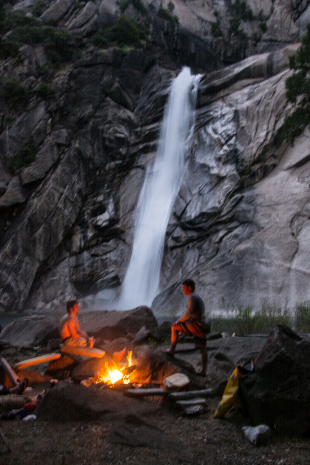
Shangri-la camp driftwood carvings.  Photo: TJ

Nice ambiance at camp.  Photo: TJ

 
Stars over the moonlit crucible.  Photo: TJ

Morning comes early. Chris and Thomas have there shuttle driver coming that evening and Darin, Tom, and I are planning to finish or camp on the lake depending on how tired we are. The water has come up about 6 inches since the previous evening due to the hot weather. We make our way down to the next gorge and immediately portage around the river right dome. After we launch back in we are soon routing through huge rapids on verbal from Darin and Thomas. Thomas gets out to scout and quickly returns with instructions: “Down the right charging a little back to the left through a big wave hole. Catch an eddy on the left but if you miss it run the right slot cutting back to the center.”

Thomas gets back in and leads the charge, with Darin only about 10 ft. back and Chris only another 10 ft. back. I hesitate for a second to give them a little space before peeling out. I drop into a maelstrom which requires an over the head brace to remain upright. As my eyes clear I see Chris is the only one in the eddy. I decide to go direct and not risk missing the eddy. I head right and prepare to drop back to the center. As I'm dropping into the slot I catch a glimpse of the stern of Thomas's boat under water, looking like a swamped boat after a swim. After coming clear of the rapid I start scanning for Thomas but nothing appears. I eddy out on the right to wait as Tom comes through behind me. Darin is already below us and has Thomas's paddle. Then, after a disturbing amount of time (maybe 15 seconds?), Thomas pops up. Darin and Tom grab him immediately and I wait in the eddy for his boat. Only a few seconds later Tom is yelling for me to come down. Tom is holding Thomas next to set of rocks against the right gorge wall. Darin and I get out quickly and drag Thomas up onto the rock. Tom lets us know that Thomas had said he couldn't feel his legs, but once out of the water, it's obvious that Thomas's left leg is badly broken and displaced. (You can read Thomas's account of what happened here: http://crossfiteastsac.com/workout/functional-fitness-its-a-life-and-death-kind-of-thing/)

We quickly stabilize Thomas on the flatest rock of the three we can reach. After a quick look at the gorge walls surrounding us the SPOT devices are fired to alert emergency personnel, as we know we won't be able to evacuate Thomas on our own. Tom is a nurse and leads the evaluation. Both of Thomas's legs are badly damaged, although the left seems worse than the right. No blood is evident so the fractures don't seem to be compound. Thomas self administers the best pain killers we have while the rest of us go about finding the best splinting materials we have. We settle on several sleeping pads, pieces of a breakdown and a sam splint. We use the ridge rest and breakdown pieces on the left leg with some duck tape to hold it all together. We then use the sam splint on the left leg with additional ridge rest and duck tape. We use a standard thermarest to elevate his legs while we place a neoair under his back to increase comfort. After splinting him we cover Thomas in a sleeping bag to keep him warm. We decide the left leg isn't well enough supported and straighten it slightly so we can tighten our splint. Chris heads over to rocks on river left to make sure the SPOT signal gets out. Then we wait.

It seems to go on forever. We keep chatting with Thomas to make sure he stays aware and to try to keep his mind off the pain. We can still see the Shangri-la waterfall where we camped the previous night. It seems a world away. As the time passes we trick ourselves into thinking that we're hearing rotor wash, but no choppers appear.

Then, at about 1 pm, about 4 hours after we pulled Thomas onto the rock, it happens. A faint drone, just like the ones we'd been tricking ourselves with, grows to a roar. The chopper appears over the gorge wall and drops a man on the rim. He shouts down to us to find out the situation and asks about options for moving Thomas. We tell him there are none. The chopper picks him back up and stays put for a minute.

Then it rises again before moving towards us and hovering directly overhead. The man begins lowering out of the chopper on the cable, spinning his way from the sky down to the rock. I comment to Tom that if the chopper gets loose towards the wall I'm diving under the rocks. Once he disengages the cable the chopper quickly retreats and lands. Only Darin is on the rock talking to him. He assesses Thomas and takes a quick history of what happened and the treatment we provided. He radios back to the chopper.

Another minute passes before the chopper is back lowering a basket on the cable. After the basket is released the chopper disappears again. He asks Tom and I to come help load Thomas onto the basket. We open up the red body bag. It isn't easy or fun to lift Thomas into the basket, as it raises his pain level through the roof, but it has to be done. Once we have Thomas positioned, we work at cinching down the straps, trapping Thomas. Like a tight mummy bag, only the center of his face is exposed. Once Thomas is secured, the chopper is summoned once again. A few minutes later the cable is lowered and we attach the basket, give a final check, and the basket is winched up into the sky with a small tag line to prevent spinning. I comment that it must be terrifying to be in the basket and he responds that he's terrified of heights and it's scary enough just to be clipped into the cable. The chopper disappears for a minute and returns to pick him up. Then, they're gone.

It's about 2 pm. We still have a lot of ground to cover. We eat a little and decide to try to push through and get out today. We boat and portage our way down to the South Fork confluence with only a minor undercut incident. We eat a little more and continue. The portaging and kayaking continue. The boating is better than I thought it would be and there are less portages, but we're only concerned with getting out of the gorges. Finally we make the Mammoth Pool bathtub ring. It should end soon. The boating and portaging continue. The reservoir is low, really low. Finally we reach the pool.

It's late, but Tom and I decide we're not camping out, so we start the crankfest. Tom remembers it being about 9 miles. The wind is bad at times. We crank on. A little over an hour in, we take a break and eat and drink. Tom thinks we're about half way. We round the corner and start seeing roads to the dam. Tom remembers that the boat ramp is not near the damn and we head to the right side of the lake after spotting a person. It turns out it's Drew, Chris and Thomas's shuttle driver. We hike up the hill a mile to the cars. We made it.

The Devil's Postpile section of the Middle San Joaquin is enormously dangerous and committing. Going in, everyone must be prepared to run several unpleasant sieved out rapids without scouting and with no (reasonable) option to portage. This hardened mentality is only required for a few sections of the river, but it is easy to let it cross over to the rest of the run where scouting and portaging options exist, greatly increasing exposure. Our team made this mistake and I and I'd guess other team members knew it while we were on the river. Our sport is usually very forgiving, until it's not, and it's only in these rare occasion where having all the cards stacked with you is important.

Sunday, August 17, 2014

North Kings

Following our third Fantasy trip, we headed back to Sacramento for some R&R (interrupted when a car was stolen outside a party at a friend's house) and some day trips on South Silver and Golden Gate.  A few days later, it was time to hop back on the horse, so we headed down to the North Kings hoping it hadn't dropped out.  After grabbing some groceries at a marginal grocery store in the central valley, Tom and I headed up into the mountains towards Wishon Reservoir. We pulled off and made camp somewhere near McKinley Grove, vowing to wake up early so that we could hike in to check the level before hiking in. We were up early, but the drive to the hike in point took longer than expected, and it was nearly 8 by the time we started hiking. When we got out to the ridge, we couldn't see the river so we traversed downstream until we got a view. From about a mile away, assessing flows was tricky. The river looked low but boatable as best we could tell, so we headed back up to the Jeep to set bike shuttle and start hiking.

TJ dropping in on South Silver.  Photo: JJ

It was close to 10 when we started heading down to Wishon Reservoir, but only a few minutes into the drive we ran into local Cali boaters Taylor Cavin and Alex Wolfgram, out for stage 1 of the Taylor Cavin bachelor party tour. Taylor and I hadn't paddled together in about 8 years (back when he was living the dream out of his Subaru), so it was good to run into him and get some numbers and a real shuttle for the North Kings. So, we quickly reversed course and headed back to the trailhead near Courtwright Reservoir to drop our gear off before running shuttle. We had about an hour packing session in the parking lot before Taylor and Tom took off to run shuttle.

About 10 minutes later a guy in a serious Jeep rolls up and asks if we have a map with any of the Jeep trails. We pulled out the trail map Taylor had grabbed and showed him that the Jeep road he wanted paralleled the trail we were going to be hiking on for a few miles. I think Alex and I connected the dots at the same time, but I spoke up first, asking our new buddy if he'd ever had kayaks on his roof rack, and following with asking him if he minded if we tied them on for a couple miles. He was all about helping us out, so in about 5 minutes Alex and I tied on 4 boats and most of the gear. Not wanting to hold him up, Alex and I start walking up the Jeep trail while spotting him through the burlier sections. Despite the rushed tie down job and brushing a few trees everything held together on the rough road and eventually we arrived where the trail departed from the Jeep road. We thanked him for cutting our hike to under 10 miles while we unloaded. I jogged back to find Taylor and Tom, who were a bit confused about where all the gear had gone until a hiker informed them of a Jeep heading down the road stacked with boats. Reunited, we head back to the boats with high spirits from our hike reducing stroke of luck.

After a little bit of boat backpack set up, we're off looking for where the trail leaves our new trailhead. Eventually, we figure it out and crank up the first hour to a small pass and the high point of our hike. From here out it will be downhill and relatively easy, but carrying a loaded boat can only be so easy. After about 5 hours of hiking with a few great meadow views but mostly just high elevation forest walking we hit one more small uphill before the final drop down to the North Kings. About 6 hours after we departed, we arrive at our campsite next to the river, surrounded by a granite wonderland and excited by the slides above and below us. A quick dinner and a few celebratory tequila shots and we're dozing off.

Tom hiking through a beautiful meadow.  Photo: JJ.

Morning is a bit cold so we laze in our sleeping bags waiting for the California sun to raise us. Tom and I scarf our oatmeal while Alex and Taylor opt for more extravagant toasted bagel, cream cheese, veggies, and avocado. We finally get geared up and carry our boat up the slide above camp, which resembles a brainless Upper Cherry slide. Still sliding down granite at high speeds is good fun. After a quick portage around an ugly hit just below camp we start bombing down great class IV slides. Unfortunately, the good clean fun is soon interrupted by the Wyoming section. Dechannelized boulder gardens separated by big ugly cascades with a few good ones mixed in, just like Wyoming. After lots of portaging, we finally make it to the first gorge.

Taylor on the put in slide.  Photo: TJ

I get out to scout and am relieved to see some good boating ahead of us. A few small drops lead into a great slide which banks off the right wall before going over a small but sticky ledge. I send the boys down on verbal leading to some good hollering for the good action. Unfortunately the gorge doesn't hold it's quality and we are forced to portage a few times before coming to the great exit drop. Three linked ledges followed by a pinch with the water banking off the right wall. I send everyone blind as the consequence is minimal. They all have great lines before I ruin the parade by getting eddied out above the pinch and dropping into slow for a little beating.

Taylor dropping into the first gorge.  Photo: JJ.

JJ early in the first gorge.  Photo: TJ

We continue on with more ugly cascades mixed in when all the sudden the riverbed gets smooth and runnable for as far as we can. Instead of savoring the rapids, we rally down linking the beautiful slides. This bombing continued for quite a while before we're forced to scout, and decide to take a break and eat lunch. The fun continues after lunch with a few teacups before the highlight of the run, a hundred yard long slide that roosts off a 20 footer. This thing is beautiful and oh so sweet left of center. Lots of hooping and hollering ensure.

TJ on some post lunch granite goodness.  Photo: JJ

Taylor early in the hundred yard long slide.  Photo: TJ

And stomping the 20 footer at the end of the slide.  Photo: JJ

Leaving the pool, we encounter some more portaging around Wyoming style cascades before arriving at the head of a gorge. It's nestled between two domes and portaging options look minimal for at least a few drops. The first rapid drops into a gnarly crack on the left but we portage right, getting into a large pool ending in an unfriendly looking rapid. After crossing the pool and checking out the rapid, I determine that it's both runnable and portageable. Tom and I help Alex and Taylor portage before driving hard left to avoid sieves but driving back right to boof the hole. Two successful lines and we're now fully walled out. We get out on both sides at the next ugly crack drop and decide that it doesn't go and is best portaged on the left. We traverse a small ledge before lowering boats to a river level ledge. Below here, the gorge opens up and we arrive at the drop we saw while scouting the water level from high up.

Portaging into the walled out pool.  Photo: JJ

At water level, the drop actually looks full of flow bouncing into an ugly pocket on the right. I decide right driving left will do the trick, but don't get enough left momentum and spend an uncomfortable amount of time battling in the pocket before earning my freedom, prompting the others to portage. The next set of slides look great but feature some terrible pocket holes. Given my recent pocket beat down, I join the others in portaging the pockets and seal launching into the super fun exit slide. Another mini-gorge greets us around the corner and its four ledges treat us all nicely. Another pool and we recognize the last drop above the lake from older trip reports, except with higher flow it looks terrible, leading to another portage. Due to the recent drought years, Wishon Reservoir is low, forcing us to paddle down some scrapey and junky class II into the reservoir, where a short lake paddle brings us to the shuttle vehicle.

North Kings is a great little adventure run in a beautiful canyon and features some super fun, low stress boating. Unfortunately the good stuff is separated by dechannelized boulder gardens which don't have enough water and huge ugly cascades (many of which have been run but aren't appealing). The hike in is easier than any of the major high sierra hikes, but it's still over 10 miles with a loaded boat (9 if you get a jeep ride). While it's certainly worth doing once (and maybe a few more times), the North Kings just doesn't stack up as classic against the true classics of the high sierra.